
Waterspouts
- juliaandrys
- Jul 28, 2020
- 2 min read

Waterspouts are violent vortices of sea (or lake) water and mist. They usually form in tropical and subtropical regions within 100 km of the coast. That said, waterspouts can and do form in the open ocean and are occasionally observed by offshore sailors. Waterspouts are also fairly common in the Mediterranean, particularly the Ionian, Adriatic, and Aegean Seas during September, when sea surface temperatures can be very high. They are also known to occur in the Great Lakes region of North America.
There are two main types of waterspouts; tornadic and non-tornadic. The major difference between the two is that non-tornadic waterspouts mainly occur during cloud and storm development, while tornadic waterspouts are a manifestation of a fully developed storm system.
Tornadic waterspouts
Tornadic waterspouts are created by a combination of wind shear and updrafts within cumulonimbus supercells. These updrafts form a circulation within the cloud known as a mesocyclone which in turn forms a violently rotating column of air on at the surface. Tornadic waterspouts can reach speeds of over 250 kts. They contain more energy, tend to be larger, faster moving, and last longer than non-tornadic waterspouts. Because of this, they are considerably more destructive. Tornadic waterspouts are virtually identical to land based tornadoes in terms of their destructive forces, structure, and formation.
Tornadic waterspouts can form in tropical, subtropical, and temperate regions, including the coasts of Australia, Europe, North America, and South East Asia. While tornadoes on land are fairly common in inland regions such as the continental United States, tornadic waterspouts are relatively rare.
Non-Tornadic Waterspouts
Non-tornadic waterspouts require humid air, warm sea surface temperatures, and atmospheric instability. They usually form in the updrafts and wind shear underneath developing cumulus clouds. Interestingly, waterspouts are associated with both cumulonimbus and more innocuous types of cumulus cloud. In fact, a cumulus cloud does not require much vertical development to produce waterspouts, which is why non-tornadic waterspouts are often called fair weather waterspouts.
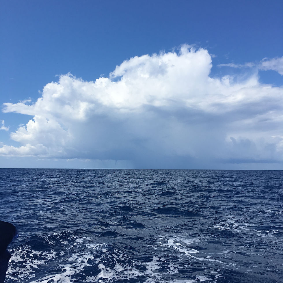
Generally, non-tornadic waterspouts are fairly narrow (between 50 and 100 m) and have wind speeds less than 50 kts. Because they are associated with the development stage of cumulus clouds, they are relatively slow moving and usually dissipate within a few minutes. This makes them easy to avoid when sailing by heading perpendicular to its apparent movement.
Non-tornadic waterspouts often appear in clusters, so if you see one, expect that others will form too. Sailing in the Tyrrhenian Sea in 2018, we observed a single cloud system that produced at least ten waterspouts. In this instance, we used our radar to determine the path of the cloud system that was spawning the waterspouts and changed our course to stay windward of it.
Warning signs of a waterspout are tubas, or funnel shaped clouds on the underside of a developing cumulus. At the sea surface, look for a dark spot surrounded by a light colored disk. The disk will then develop a cascade of spray that will eventually connect with the elongating funnel cloud, forming a mature non-tornadic waterspout. While non-tornadic waterspouts are difficult to forecast with skill, you should be on the lookout for their formation whenever the conditions are conducive to strong convection.


コメント